獅山古道 | Famous Attractions in Hsinchu County | Top Taichung City attractions, famous shopping districts, natural landscapes, museums, and Instagrammable landmarks for family and group travel | Taichung City Tourism

獅山古道

Taiwan Guide Explore Attractions Current city: Hsinchu County / 22 cities/counties
Taiwan Guide

Explore Attractions

Browse famous attractions across Taiwan, including offshore islands.

22 cities/counties
Spot

獅山古道

獅山古道 is a historic attraction in Hsinchu County. The listing is compiled from official Tourism Administration open data, usable photo records, and attraction information.

獅山古道 is a historic attraction in Hsinchu County. The listing is compiled from official Tourism Administration open data, usable photo records, and attraction information.

Opening hours and on-site rules follow official notices.

Site travel notes

Attraction Guide

This Hsinchu County travel stop is listed locally as "獅山古道". This page keeps the local name while organizing the location, opening notes, transport reminders, and sources for trip planning.

This attraction can fit into a Hsinchu County itinerary. When comparing nearby stops, consider travel time, transport options, and how much energy you want to spend that day.

This attraction is included here because it can add a useful travel stop to a Hsinchu County itinerary. It works for a half-day visit, a nearby walk, or a smooth link between attractions in the same area.

Use the map link and the saved local address as the location reference, then choose driving, walking, or public transport based on your route. For mountain, island, or high-traffic spots, leave extra time for transfers and queues.

This guide is written from public travel information and our own editorial notes, focusing on details useful for visitors. Live reviews from outside platforms are not rewritten into this page.

FAQ

Where is this attraction?

The local listing name is "獅山古道". The saved local address is "新竹縣峨眉鄉六寮60-7號(獅山茗旁)". Use the map link to confirm entrances, parking, and public transport routes.

What are the opening hours?

Opening hours and on-site rules follow official notices. Check official notices or on-site information before visiting.

How should I plan this stop?

This attraction works well with other stops in Hsinchu County. Plan the order by travel time, transport distance, weather, and how long you want to stay.

What is the source of this attraction page?

We refer to public travel information, our editorial notes, and verified traveler interest. Reviews from outside platforms remain on their original platforms and are not copied or rewritten here.

Content Source Tourism Administration, MOTC open data 2026-07-04

Check before you go

獅山古道 Live view and weather

Check the latest conditions before choosing rain gear, layers and arrival time.

Live camera

Nearby camera
獅山古道 Live camera

This camera is near the attraction and helps with area weather; crowds and clothing may differ at the attraction.

Camera location
Highway 3 at 98K+000 (about 6979 m from this attraction's official map point)
Source checked
2026-07-27
Open official live camera

This camera is in the surrounding area, about 6979 m in a straight line from the attraction's official map point. It can show sky, rain, cloud, fog and visibility, but it is not inside the attraction and cannot represent visitors, facility access or clothing; check attraction and road notices separately.

Live views are for trip planning only. This site does not identify faces or individuals.

Attraction Video

獅山古道 Video Guide

Preview the setting and visit highlights. Videos are prioritized from official or operator channels.

Watch on YouTube
Traveler review source

Google Reviews

Google Maps reviews change over time. Open Google Maps to see the original reviews, latest rating, and newest comments.

4.4 Overall rating 115 reviews

Helpful Highlights

4 reviews
謝瀚霆 5.0/5

It's a great trail, basically a bit like an industrial road, so there are no steps, just slopes. It connects to the Liuliao Ancient Trail in the middle, and coming back from the Liuliao Ancient Trail, you can complete a loop.

2 months ago Google Maps
Wen Lo 5.0/5

You can connect to the Liuliao Ancient Trail and walk around it.

9 months ago Google Maps
JR Hsu 5.0/5

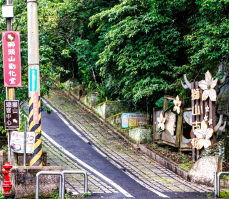
Navigate to the Lion Head Mountain Visitor Center by car; the entrance to the ancient trail is right next to the archway. This is the lion's tail; you can walk to the Quanhua Hall at the lion's head, a one-way trip of 3.8km, mostly paved roads and steps. The highest point of the trail is Wangyue Pavilion, where you'll find the Hsinchu County border and a small shop. Take a break here and have some herbal tea. From the dirt road next to it, you can walk to the triangular point, at an altitude of 492m, which is also a certified point on the "Little 100 Peaks" hiking guide. You can see Egongji Mountain in the distance. Return to Wangyue Pavilion via the same route and descend towards Quanhua Hall. After passing a large rock face, you'll reach the temple complex, where there's a supply depot. If you're traveling with others, you can leave your car here; otherwise, you'll have to walk back to the visitor center like me. The entire trail is relatively easy to walk, suitable for a family outing. After descending the mountain, stop by Nanzhuang for some shaved ice to end a pleasant day.

a year ago Google Maps
黃大帝 5.0/5

113.8.2 From Lion's Tail, go uphill all the way to Moon Gazing Pavilion, then downhill to Lion's Head and back to Lion's Tail. It's about 10km and took 5 hours (30 minutes for lunch break at Lion's Head). About 80% of the way is shaded by trees, and there are several temples and toilets. Be careful as the road gets slippery near Lion's Head!

a year ago Google Maps

Things to Notice

1 reviews
J. W. 3.0/5

It is recommended to travel with two or more people, as the trails are not clearly marked and it is easy to get lost. It is also recommended to bring trekking poles to prevent knee injuries. (You can take the Taiwan Good Hike Shishan Line.)

2 years ago Google Maps

Review source: Google Maps Updated: 2026-07-07 01:07

Sources and ranking basis

This page cross-checks official public information, on-site editorial work, and verifiable traveler interest instead of relying on an old or single ranking list.

  1. Official and public sources: Tourism Administration, MOTC open data , Official Info , 包毛登山旅遊日記 , Highway Bureau Provincial Road CCTV , Central Weather Administration . Used to confirm the attraction name, address, official links, transportation notes, and basic travel information.
  2. On-site content: Introductions, FAQs, and transportation details are organized into readable original site content. External reviews are not copied into this page.
  3. Ranking and score: The score uses "official inclusion + traveler interest": official sources help decide whether the attraction belongs on the list, while verified ratings, review volume, one-year and five-year activity changes, search interest, and on-site engagement affect the visible recommendation.
  4. Traveler interest references: Google Maps, Tripadvisor, news reports, and public social discussion may be used only as checkable references. The site records usable statistics, source links, and check dates, but does not copy full reviews or posts.
  5. Use of external information: The site uses public, verifiable information for summaries and organization. It does not republish full external reviews, social posts, or entire official pages; images and external materials follow public links, licensing, or source notes.

Page last organized:2026-07-04