龍騰斷橋、南斷橋 | Famous Attractions in Miaoli County | Top Taichung City attractions, famous shopping districts, natural landscapes, museums, and Instagrammable landmarks for family and group travel | Taichung City Tourism

龍騰斷橋、南斷橋

Taiwan Guide Explore Attractions Current city: Miaoli County / 22 cities/counties
Taiwan Guide

Explore Attractions

Browse famous attractions across Taiwan, including offshore islands.

22 cities/counties
Spot

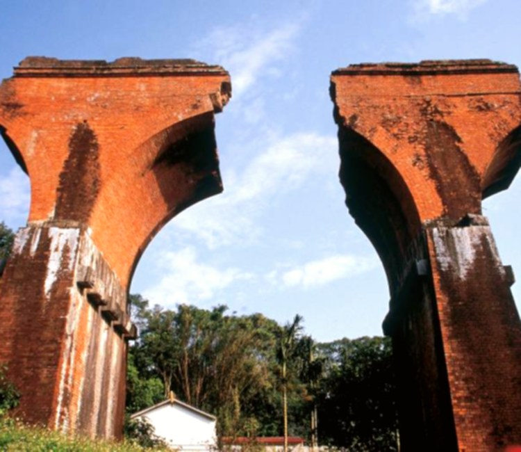
龍騰斷橋、南斷橋

龍騰斷橋、南斷橋 is a scenic attraction in Miaoli County. The listing is compiled from official Tourism Administration open data, usable photo records, and attraction information.

龍騰斷橋、南斷橋 is a scenic attraction in Miaoli County. The listing is compiled from official Tourism Administration open data, usable photo records, and attraction information.

Opening hours and on-site rules follow official notices.

Site travel notes

Attraction Guide

This Miaoli County travel stop is listed locally as "龍騰斷橋、南斷橋". This page keeps the local name while organizing the location, opening notes, transport reminders, and sources for trip planning.

This attraction can fit into a Miaoli County itinerary. When comparing nearby stops, consider travel time, transport options, and how much energy you want to spend that day.

This attraction is included here because it can add a useful travel stop to a Miaoli County itinerary. It works for a half-day visit, a nearby walk, or a smooth link between attractions in the same area.

Use the map link and the saved local address as the location reference, then choose driving, walking, or public transport based on your route. For mountain, island, or high-traffic spots, leave extra time for transfers and queues.

This guide is written from public travel information and our own editorial notes, focusing on details useful for visitors. Live reviews from outside platforms are not rewritten into this page.

FAQ

Where is this attraction?

The local listing name is "龍騰斷橋、南斷橋". The saved local address is "苗栗縣三義鄉龍騰村9-5號". Use the map link to confirm entrances, parking, and public transport routes.

What are the opening hours?

Opening hours and on-site rules follow official notices. Check official notices or on-site information before visiting.

How should I plan this stop?

This attraction works well with other stops in Miaoli County. Plan the order by travel time, transport distance, weather, and how long you want to stay.

What is the source of this attraction page?

We refer to public travel information, our editorial notes, and verified traveler interest. Reviews from outside platforms remain on their original platforms and are not copied or rewritten here.

Content Source Tourism Administration, MOTC open data 2026-07-04

Check before you go

龍騰斷橋、南斷橋 Live view and weather

Check the latest conditions before choosing rain gear, layers and arrival time.

Live camera

Nearby camera
龍騰斷橋、南斷橋 Live camera

This camera is near the attraction and helps with area weather; crowds and clothing may differ at the attraction.

Camera location
Highway 13 at 51K+800 (about 3549 m from the Tourism Administration map point for 龍騰斷橋、南斷橋)
Source checked
2026-07-27
Open official live camera

The Highway Bureau camera at Highway 13 at 51K+800 is about 3549 m in a straight line from the Tourism Administration map point for 龍騰斷橋、南斷橋. It shows nearby sky, rain, visibility and road conditions. It is on a nearby road rather than inside the attraction and cannot represent visitor, opening or facility conditions or support reliable clothing checks; review attraction and road notices separately.

Live views are for trip planning only. This site does not identify faces or individuals.

Attraction Video

龍騰斷橋、南斷橋 Video Guide

Preview the setting and visit highlights. Videos are prioritized from official or operator channels.

Watch on YouTube
Traveler review source

Google Reviews

Google Maps reviews change over time. Open Google Maps to see the original reviews, latest rating, and newest comments.

4.3 Overall rating 24323 reviews

Helpful Highlights

5 reviews

Quite a nice area, even the bridge itself isn't too special. The railway car is cool, but only the long tour will take you to the bridge you see everywhere. The shorter trip only takes you to a small old street.

8 months ago Google Maps
Carolina Lee 4.0/5

The long teng bridge ruins a memorial earthquake in 1935. It experienced yet another earthquake in 1999 and three government decided to rededicate the bridges remains as a monument to the two deadliest earthquake in Taiwanese history. There are two locations where you can view the bridge. One is accessible by taking the old mountain rail bike line and the other by taxi or car. Pretty good experience if you go by the rail bike.

9 months ago Google Maps
Ken Sitzwohl 4.0/5

Parking lot with NT$100 fee a short distance from the bridge remains. Stairs allow a climb to the top at each end.

7 months ago Google Maps
HS Lim 5.0/5

Collapsed railway bridge in a forested area. Need personal transport to get around.

3 months ago Google Maps
Nicole Huang 5.0/5

Great sightseeing place. The broken bridge was built for railroad use, an earthquake in 1935 destroyed the it. We came here years ago when it was just a sight to see. Now the city has made it into a wonderful attraction with convenient parking and cafes around the area. There is even a walking trail to get really close to the bridge.

6 years ago Google Maps

Things to Notice

0 reviews

There are no cautionary written comments to summarize yet. Check the latest reviews before visiting.

Review source: Google Maps Updated: 2026-07-07 00:15

Sources and ranking basis

This page cross-checks official public information, on-site editorial work, and verifiable traveler interest instead of relying on an old or single ranking list.

  1. Official and public sources: Tourism Administration, MOTC open data , Official Info , Adam&Seven , Highway Bureau Provincial Road CCTV , Central Weather Administration . Used to confirm the attraction name, address, official links, transportation notes, and basic travel information.
  2. On-site content: Introductions, FAQs, and transportation details are organized into readable original site content. External reviews are not copied into this page.
  3. Ranking and score: The score uses "official inclusion + traveler interest": official sources help decide whether the attraction belongs on the list, while verified ratings, review volume, one-year and five-year activity changes, search interest, and on-site engagement affect the visible recommendation.
  4. Traveler interest references: Google Maps, Tripadvisor, news reports, and public social discussion may be used only as checkable references. The site records usable statistics, source links, and check dates, but does not copy full reviews or posts.
  5. Use of external information: The site uses public, verifiable information for summaries and organization. It does not republish full external reviews, social posts, or entire official pages; images and external materials follow public links, licensing, or source notes.

Page last organized:2026-07-04